South Couloirs Grade II, Class 3+, Moderate Snow
6.5 miles; 3,157 ft. elevation gain
October 3, 1998
"Iím not sure, but I think I just ran over a tarantula." I said to Ross as we zipped through the scrubland of western Pueblo County. The Wet Mountains were filling the windshield while the sun dipped ever lower - somewhere between over the mountains and below my visor. Finally we trucked up a steep switch-back that would relieve my eyes and deposit us in Wetmore, gateway to the Wets. Immediately, we were transformed from the desert-like terrain of Pueblo into the glowing aspen and deep pine of San Isabel National Forest.
Even in the quickly dimming dusk, aspen radiated in hues of yellow, gold and green. A waxing moon reflected more than enough light to continue the display. We oohed and ahhed until we simply ran out of things to say. Rounding a bend shortly after traversing the length of a meadowy area called Silver Park, our first view of the Sangre de Cristo Mountains greeted us to the Wet Mountain Valley. We coasted down into Silver Cliff and Westcliffe. The gas tank needed topping at the last station south of town and I checked in at home to let my wife know we had made it. Then we turned our sights to the national forest access road to the South Colony Lakes Trailhead.
To say the road beyond the two-wheel-drive parking area requires four-wheel-drive oversimplifies the difficulties of this trail that begin almost immediately. Four-wheel-drive should be fortified with plenty of ground clearance and skid plates. Even well equipped, it took us a bit over an hour to cover the darkened, 4-plus miles to the trailhead at 11,040 feet. We noticed patches of wet snow along the way starting at about 10,500 feet. Snow lingered where the sun had not happened upon it; the area was mostly dry otherwise. We were amazed to find only one other vehicle at the parking area and negotiated a flat spot then began to settle in for the night.
|
0600 brought the ever so friendly chirps of the alarm. We slowly acquiesced to the idea of getting out of our warm sleeping bags and into our cold climbing clothes then munched a quick breakfast. The chill morning air got our attention as did the accompanying breeze which washed over us as we emerged from the bed of the truck. Without pause, we started up the trail toward the lower South Colony Lake and struggled to find an early morning pace. Looking for a path through to the west of the lake, we barged through some willows and happened upon a pair heading out of their camp. They were going to have a look at the North Buttress of Crestone Peak and we wished them well. On to the north flanks of Broken Hand Peak and into the slope below Broken Hand Pass we went, plodding through snow that began as one to two inches and quickly became several inches deep. |
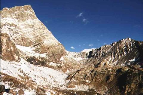
| The notch of the pass now squarely in our sights, we found a pace on the steepening, snow covered slope and gained elevation quickly. We noticed wisps of cloud zipping over our heads from west to east and spin drift cascading from the notch . We both knew what was waiting for us. Our estimate is that the wind through the notch was easily fifty knots and perhaps higher. We did not linger and escaped onto the south ridge of the Needle to where the wind blew at merely 30 knots at 12,900 ft. Sunshine accompanied us for the first time as we traversed below the ridge towards the couloirs and it helped combat the wind-chill. All before us was white with snow except the rock ribs that defined the walls of the peak. | 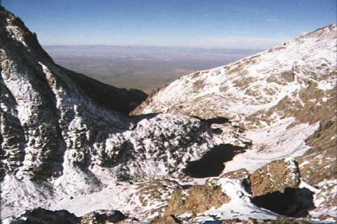 |
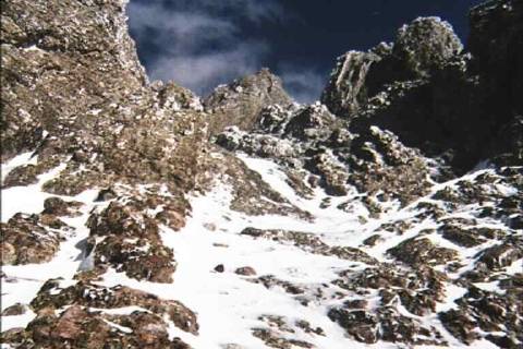 |
In time, the eastern of the two ascent couloirs was before us and our world turned vertical as clouds rolled in to obscure the sun. Inspecting the route, we could see that snow lay deep in the cleft of the couloir but rock broke through semi-regularly. We started up. Kicking through the snow generally led to something solid underneath. When it did not, the snow held underfoot sometimes and gave way just as often. Hand holds, while not plentiful, were adequate though many required the snow to be brushed away and/or the immature ice to be pounded off. The rock itself was wonderful to hold and solid, the smallest hold accepting the edge of a boot or a gloved thumb and finger with comfort. Ross and I fell into a pattern of working deliberately up the obscured rock and slowly gained height in the ever steeper gully. |
Pausing occasionally to check our progress, we noticed the Sierra Blanca thirty-five miles to our south, the four major peaks easily identifiable. The climbing was thoroughly enjoyable and this enjoyment probably led to a route-finding error in which we climbed the eastern couloir through an array of class four moves before realizing we needed to traverse left to the next couloir. We began a traverse of the rock rib which separated the two troughs and found ourselves a bit too high to simply scramble into the western couloir. I led across the face of the rib and stemmed around a corner before slowly lowering onto a positive hold and into easier terrain. The move around the corner, we agreed, was lower fifth class but the exposure was minimal.
Continuing our deliberate, snowy scramble we entered into ever deeper snow and we exchanged ideas about the prospect of the downclimb if we continued much farther. We discussed abandoning the climb at 13,600 feet but decided to continue as long as the upclimb didnít increase in difficulty. It didnít and we rose in a rhythm of solid class three moves to a sloping shelf that connected the two couloirs. Easier ground was before us and we stopped to rest before ascending the last steps to the still unseen summit. Clouds thickened and streamed across the area reducing visibility to about 100 yards, posing no danger but yielding no view.
Continuing, I was amazed to see the summit cairn rise from behind a short rib in the midst of an area no larger than a small room. We were relieved and elated. Sheltered from the wind by the couloirsí walls we expected to be punished by the wind on this exposed summit but welcomed only a modest breeze. We ate and drank to our half-success knowing that the remainder of the bill was left to be paid ñ the descent. We had just begun to leave the summit when the clouds parted from Crestone Peak to the northwest and I followed its lines down to Bearís Playground and across to Humboldt Peak. There was time for two photos before the curtains closed again, the scene barely etched into memory. We turned our back on the summit without another pause.
We decided to avoid the steep ascent couloirs that though full of positive holds, held enough snow and ice to make us look for an alternative. Directly to the south of the summit lies a broad shallow couloir that appeared to provide quick escape down the mountain and did for about 700 vertical feet. The couloir provided relatively effortless downclimbing but grew narrower and steeper until, at roughly 13,400 feet, the bottom dropped out into a tiered chimney with no way to descend by hand and foot. While I paused to assess, I told Ross to stop descending while I judged what our options were. It was then I saw the blue webbing and shiny rappel ring laying to the side, its other end unseen within the snow. We werenít the first to descend this couloir and certainly werenít the most prepared. I yelled to Ross that it wouldnít go and he scrambled left over a rib to scout an alternative. I scrambled up after him and heard him say he found an out as I crested the rib.
Again we were on easier ground that would grow more tedious and we repeatedly traversed ribs eastward when faced with an obstacle. Snow and ice was no longer a persistent companion and we were left with clean, solid rock on which to scramble down. As unenjoyable as downclimbing is in general, the sustained nature of the achingly slow descent brought out our best and we ticked off move after considered move. All through the descent, we kept our wits and sustained our teamwork through the difficulties. I was secretly second-guessing our decision not to descend our ascent route but did not broach the subject with Ross; that would not have been productive at all. We found ourselves with one last test before reaching the talus below and after scouting two routes into the next, sheer-walled couloir that proved fruitless, we paused and regrouped.
Ross set out to reassess one of the routes we thought wouldnít work and I set out right for a possible retreat. "Tom! Itíll go!" I hustled back to see Ross peeking from behind an abutment that led to a series of ledges. The going was slow but we found ourselves deposited on a shallow talus pile at the base of what was probably the western of the two ascent couloirs. Above us was an impressive face that guards the opening to that couloir. On casual ground now, we traversed over rock and grass to a point 300 feet below the south ridge of Crestone Needle. We rested and were finally able to discuss the choices we made on descent. We both second-guessed ourselves about not descending our ascent route but agreed that the prospect of the deep snow and icy rock would have proven much more treacherous than the fairly clean, albeit arduous scrambles we had just left behind.
I picked out a spot on a rib that jutted west from the south ridge that I believed Broken Hand Pass lay behind. We commenced an ascending traverse over the snow covered grass slope and into a scree chute. Snow and scree donít produce the most solid footing but we gained the top of the rib and the pass was a mere twenty feet away. The wind again hastened our passage through the notch and down the drifted east slope we went, skidding and plodding. I turned to see Ross actually glissading the powder, ice axe stowed. I lowered into the snow and set off, easily controlling direction and speed over and around rocks in a sort of half standing, half seated glissade. We dropped about 500 feet in ten minutes, not in too much of a hurry, then plodded some more to the lower lake and onto flat ground. We hiked the fishermanís trail around the lower end of the lake and through willows to the main trail. After a bit of loping along in silence, the trail register came into view ending the long trek and I knew that there was one thing we both needed more than anything else - dry socks.
We were pretty whacked from the steady exertion but revelled in what we had just done; our own personal victories. The summit and the return were the milestones but it was the act of climbing that made an impression. The myriad of details that fill the hours between start and finish, instances that blurred into the next, remained to be savored. And now that the deed was done, bittersweet reflection combined with fatigue to induce a philosophic mood. Itís no wonder that mountains are a metaphor for hardships and worthy endeavors everywhere. Those metaphors symbolize the very traits of even the modest mountaineer: strength, skill, courage, perseverance, composure. I laughed at the prospect that those traits really pertained to us. But here we were, safe and successful after scaling a worthy peak in far less than ideal conditions.
With just an hour or two of light left, we changed into dry clothes and dove into our down bags and faded off to where we hoped sleep would find us. With the fading light, the temperature dropped and the wind freshened in great gusts. A low rumble would grow in the trees and we learned quickly to judge the direction, timing and strength of the blows of cold air that roared onto us. Sleeping fitfully, I was aware of sleet pelting the truck around midnight and was pleased to see no intrusions of wind or water into our toppered cocoon. 0600 brought that chirping sound again and without opening his eyes, Ross said classes would probably be cancelled today. I answered that at the very least buses would be running two hours late.
The wind was fierce and snow still fell on top of the three to four fresh inches that lay around us. Not climbing Humboldt Peak was a no-brainer and we made ready to motor downhill. After brushing snow and scraping ice, we set off. An hour and three miles later, we stopped for a clothing adjustment and could see the upper slopes of Humboldt Peak, great plumes of white powder streaming upward and eastward. Nearing the end of the road, two ranchers stopped us to smirkingly ask where we had picked up all the snow that was now cascading over the windshield. "Up there," we said pointing over our shoulders. They agreed climbing Humboldt today would not have been a good idea. I wonder what they would have thought if we told them weíd climbed the Needle yesterday. Hot coffee and a hearty breakfast in Silver Cliff completed our recovery and sent us on our way home.