14,130'
August 2-4, 1996
(West of Aspen, Colorado)
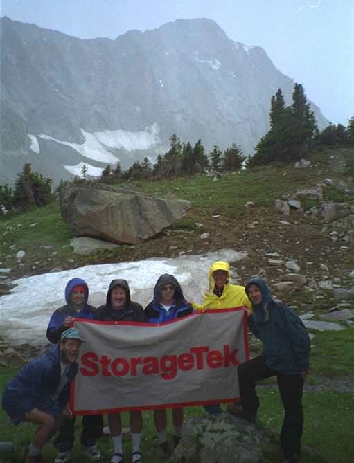
Climbing for the Emily Griffith's Center Peak Challenge
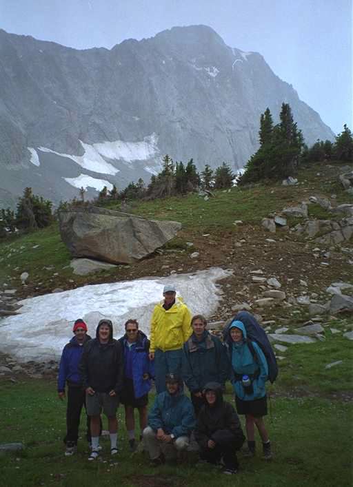
Who: Steve Parker, Chip Furlong, Kirt Schumann, Dave Hostetter,
Gary Dunlap, Bob Lindsay, Debbie Wagner, and Steve Howbert
PhotoCD pictures have been embedded in this Trip Report.
When we originally picked Capitol for the Peak Challenge, we were counting on a fairly small group of people who would climb. The number rocketed up to about 12 people, and gradually settled back down to eight. This was still a big number for one of Colorado's more dangerous peaks, but everybody in the group was an experienced climber, and most of us knew each other pretty well. It took a while to coordinate carpools, meals, tents, etc, but finally we were on our way.
Chip and I headed for Leadville Thursday at 7pm, to stay at a friends house that is under heavy construction. Since all we needed is a floor and a roof for the night in case it rained, that was fine. We just didn't want to end up setting up the tent in the dark and the rain before we even started walking.
At Rochelle's recommendation,we ate breakfast at the Columbine Cafe that morning, right on Harrison St (the main street in Leadville, about a block from the stoplight). I'd highly recommend this place to anybody who asks where to eat in Leadville.
|
We jumped in the Subaru for the trip over Independence Pass and down to "Old Snowmass". We got to the trailhead at about 10am, reorganized the packs, and took off on the walk at about 10:30am. The walk into Capitol Lake is a 6.5 mile walk up Capitol Creek, looking straight at the imposing North Face of Capitol most of the way. It's a fairly easy trek in, although by the end of it, you're fairly bushed. The weather wasn't too bad, maybe 50% overcast, and a little cool (perhaps 65-75 degrees over the course of the day). |
Before we left, we read Borneman's, Roach's, and Dawson's description of the trip in, but now we're sure they all spelled the name of the peak incorrectly. It should be Cowpital Peak. There were range cattle (and the resulting "output" of said cattle) everywhere, and even a couple of dead cows on the way in (one was decomposing right in the middle of the trail). So much for being able to smell the wildflowers...
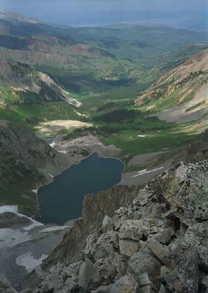
We crested the high meadow just before the lake at about 2pm. There were cattle in the meadow by the lake, just laying around content with their lives. We started looking for the two campsites that people recommended. The first was on a bluff on the immediate right as you come over the crest into the meadow. Since most of this was covered in fresh "cow output", we skipped this, and headed for the high knoll just to the northeast of the lake. After the walk in, going up the 100 vertical feet to this knoll wasn't all that fun, but there were quite a few places to put a tent (we'd need five spots by the time everybody made it in).
|
We set up our tent, and walked down to the lake to filter some water.We met the "cattle rancher" on his horse as we were walking to the lake from the knoll. We continued on to the lakeside, and took a nap on the rocks at the lake shore, looking straight up at the north face of Capitol. We must have stayed around there for about an hour, and when we headed back for the tent, the rancher was gone, and so were all of the cows. At least we wouldn't have them to worry about. (side note: That rancher must have one hell of a grandfather clause, to let range cattle graze in a Wilderness Area) |
The wildflowers in the meadow were georgeous. There were both white and blue columbines, red, orange and maroon paintbrush, blue elephant bells, and many, many others. It was one of the most colorful meadows I've seen in a long time. From the lake, you can watch people descending the knife edge, and on the north-east side of K2. We were VERY surprised to see people still up on the ridgeline as late as 4:30pm, given the fact that the lightning was starting to kick up big-time.
Over the next few hours, the rest of our group showed up in twos and threes. Steve, Gary and Debbie plodded in, followed by Bob and Denise (who wasn't climbing, just camping) and finally Kirt and Dave. There was room for a couple more tents up on the knoll, but most newcomers started setting up tents down in the meadow (even though this is "not allowed".) We had dinner (Lipton noodles mixed with tunafish), had everybody set their watches for 6:00am, and hit the tents at dusk for a fairly uneventful night (at least until early morning.) One interesting note, however, is that we heard MANY rockslides during the night. This is probably one of the most "unstable" areas I've been so far.
|
It started raining about 5am, and when the watches went off at 6am, we decided to wait it out. The rain stopped around 6:45, at which time we rousted everybody out of bed, ate breakfast, while watching people start the trek up the Daly Pass in the rain. At least 9 people left before us. We eventually started up pass around 7:20am under overcast skies. We had decided in camp that we'd make a "go/no-go" decision once we got to the pass and could see the "incoming weather". By the time we got there, the skies were starting to clear up slightly, and we decided to continue. |
We dropped off the eastside of Daly Pass about 200 vertical feet (not the 400+ that the books mention.) This left us with a couple interesting downclimbs, but all in all, not too difficult. From what I can "guess" on the topo map, we probably followed the "12,400' contour" around to the south, and eventually turned to the west to head towards K2. I believe that we may have turned towards K2 (point 13,664) a little early, and ended up having to do some moderately difficult scrambling. It would have been easier to have stayed near the bottom of the basin as it curves around to the south-west (this would be the way we came out). By this time, we had split up into three groups. Bob and Gary were quite a ways out in front, followed by Kirt, Dave, and Steve H. Chip, Debbie and I brought up the rear. While we were coming up the basin, we had to take shelter during a brief hailstorm that lasted about 15 minutes. Debbie was a little nervous about continuing, so I stayed down low with her while Chip scrambled up to the ridge to check on incoming weather, and to see if he could catch "group 2". The storm cell passed, and after about 20 minutes, Debbie felt comfortable enough to continue on up.
|
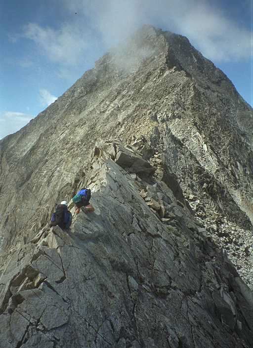
Eventually, either route led to the east-west ridge running between K2 and Clark Peak. This is a fairly impressive ridge to stand on looking down into the Pierre Lakes basin. At this point in time, I understood why another friend had told me you can't make it from Snowmass Peak over to Capitol. We walked this ridgeline due west until we got to K2. This is where many of the "suggestions" on how to get around K2 differ. Some say go straight up from the east, over the top, downclimb the west, and continue; some say to climb around the west. Debbie and I saw Chip going up the east route, right over the top, and down the west, but when we followed, Debbie didn't feel comfortable with the down-climb. We retraced our route a little, and ended up working our way around the west side about 30 vertical feet from the summit. Knowing what I do now, I'd say that we should have dropped off the west side considerably lower, since the saddle on the knife-edge side is about 60 feet below the summit. It would have been a little easier, and besides, it's where all the cairns and the trail were. |
|
By this time, Debbie appeared more and more uncomfortable with the rocks, routes, and exposure, especially as we started across the knife-edge. Adding this to the fact that my "12:00pm turn-around signal" had gone off, I decided that we should turn around. The east-facing face of Capitol where we could see the other climbers looked as difficult as the west-face of K2, and I didn't want Debbie up there if she wasn't sure of herself, and I knew from the speed she was moving, that it would take at least another hour and a half to summit. The storm clouds on the horizon were pretty ugly, her legs were pretty scraped up, and she had a pretty bad cut on her finger. We turned around on the knife edge, and started working our way back around K2 to a place we could sit and get out the medical kit to fix her finger, and wait for the others. |
***** I'll eventually add Chip's description of the final part of the climb, since I had to turn around with Debbie
|
|
|
The six of our group who made the summit, met a father with his 7 1/2 year old girl who had just finished all 54 14'ers. Talk about starting young...
***** Back to my part of the story
|
We went back around the west side of K2 via some interesting chutes, coming back out on the eastern ridgeline much lower than where we left it. It's always amusing to me how easy it is to spot the cairns on the way back when you know where you're going, than to spot them on the way up. We butterfly bandaged her finger, and decided that we'd better get a head-start on the rest of the group, knowing they'd easily catch us. We worked back down the east-west ridge, where I wanted to jump in a HUGE snowfield and glissade down to the bottom of the basin. She wasn't comfortable here either, so we down-climbed huge slabs of granite until we hit a bluff, and had to jump in the snow. I LOVE this part of the down-climb, and virtually skiied out the field to the bottom. We could easily have saved a half-hour downclimb if we had jumped in at the top, but c'est la vie. Once she got comfortable in the snow, Debbie also had a good time sliding this field. |
|
We worked our way north-east back towards the Daly saddle. Gary (and another guy named Frank) caught up to us during this part of the walk out, and we saw Bob trying to parallel our route in the high bluffs to the north-west. He was having an "interesting time", and eventually decided to down-climb to us, rather than stay up in that exposed, rotten rock (we didn't really want him above us anyway... the possibility of rocks falling was far too high). Bob had slipped at one point up there, and really whacked his shin on a rock, landing hard and hyper-extending his right thumb. We packed a zip-lock bag with snow, and had him carry it out in his hand to knock the swelling down. Luckily he was able to walk out under his own power, but will be seeing a doctor soon to make sure everything's OK (post story note: Bob was fine). |
Anyway, we worked our way back to the saddle, and headed down into camp, arriving at roughly 3pm (boy, was that 100 feet up the knoll to the tents a drag). Besides a couple of blisters, though, I felt OK. By the time we got to the tents, the weather was starting to take a turn for the worse, and I grabbed a bunch of water bottles and a filter, and headed back over the front of the knoll for the lake. I met Chip coming down the trail from the pass, and he turned up towards the lake to refill the bottles he was carring as well. Kirt, Dave, and Steve H. were about halfway down the pass at this point, so we knew everybody was OK. It was a busy Saturday on the peak however. Counting the nine who left before us from Capitol Lake, ourselves, and at least four groups of three we saw heading back down to Moon Lake, that made 29 people. That's quite a few for this hard of a peak. It kinda makes you wonder what Grays/Torreys, Sherman, Lincoln/Democrat/Bross, or Quandry were like, not that I like conventions...
|
We filled a bunch of bottles from the lake, and as we were walking back towards camp, the boomers started. They were pretty active to the northwest, although it was just sprinkling lightly at Capitol Lake. The light rain continued for about a half hour, then let up for another half hour. It was at this time when we saw two more people just crossing the knife edge on their way back down. Debbie and Gary decided they were going to head for home at this time, and broke down their tent, packed up and got ready to go. It started raining pretty hard, so we all ducked under the trees to wait it out. The rain lasted about 15 minutes, and when it let up, Gary and Debbie took off. We had about 45 minutes before the thunderstorms really kicked in, raining hard, and lightning everywhere around us, instead of just to the north. All we could think about was those two people we'd just seen on the knife-edge, and how they were in a really bad place at a REALLY bad time. This storm lasted about an hour, and then the wind kicked in and blew the storms out. We did see the two guys coming down the saddle trail about an hour and a half later. I'll bet they'll never forget that trip down. Kirt and Dave decided to take off for home around 5pm. |
Steve H, Chip and I made dinner, and then just sat around on the rocks in the wind and sun looking at a storm that was kicking up over the trailhead (I still don't know if Gary, Debbie, Kirt and Dave make it out dry yet). We shared our time with an overweight marmot who apparently wasn't too spooked by humans being close, but with the number of cows that we saw on the way in, I doubt that marmot was really afraid of anything.
That night was dry, but very windy. It didn't really let up for the whole night. None of us really got a good nights sleep, although by all rights we should have been in a coma from the day's activities. We got up at daybreak, broke down camp in the wind, and headed for the valley where we'd stop and have breakfast away from the wind. It's a sad state of affairs when you leave for the car earlier than you left for the peak the day before.
The trip out was uneventful and pretty quick. We reached the cars in three hours, including the time we spent for breakfast. Even though we had to cross Capitol Creek at least four times each way, Steve P (my humble self) managed not to fall in the creek and get his boots wet! Much unlike the climb at El Diente two weeks ago...
We stopped for a good lunch at the 19th Street Diner in Grand Junction, then headed east. We hit TERRIBLE traffic on I-70 coming back down, though. It wasn't too bad until you got past the Tunnel. They had opened a third east-bound lane through the tunnel by the time we got there, and traffic was moving OK. It started backing up just below Loveland, however, and was pretty nasty until we got clear to the Morrison exit, where all the Phish Phans were exiting. Traffic around there (as we tried to turn north to 93) was brutal because of phans trying to buy tickets on the offramps, walking in the roads, and generally wreaking havoc on the traffic patterns.
I heard on the radio the next day that they set the all-time traffic record at the tunnel on Sunday. Bummer. I guess I'll have to start working weekends, and climbing on weekdays... Or maybe just stay up in the mountains all the time.
Steve

=============================================================================
Steve Parker                          Internet : CRMTR at ParkerPress dot com
Disclaimer - These opiini^H^H damn! ^H^H ^Q ^[ .... :w  :q  :wq  :wq! ^d  X ^?
exit X Q  ^C ^? :quitbye  CtrlAltDel   ~~q  :~q  logout  save/quit :!QUIT
^[zz ^[ZZZZZZ ^H  man vi ^  ^L  ^[c  ^# ^E ^X ^I ^T ? help  helpquit ^D  ^d
man help ^C ^c help exit ?Quit ?q CtrlShftDel"Hey, what does this button d..."