14,159'
July 20, 1996, (Southwest of Telluride)
Who: Steve Parker and Chip Furlong
When Chip said he was going "down south" to try El Diente again after getting rained out last month, I figured it would be a good conditioning climb before climbing Capitol Peak in a couple weeks. I didn't know much about the San Juans at that time, but Chip is a virtual walking encyclopedia of trivia about roads, towns and mountains in Colorado, and I knew I'd learn alot more about the high country on the way.
We started the drive Friday at 6:15am from Broomfield, heading for lunch in Telluride (at the brewery, of course). On the way in to Telluride, it was very obvious they'd just received a HUGE amount of rain, as there was about a 5+ mile stretch of road which has been covered by a red mud landslide only a couple days before. We were glad that the storm had passed, and that we weren't trying to climb during that deluge. Nothing is worse than serious backcountry rain 24 hours per day (well, almost nothing, I forgot about work).
|
We headed south-west out of Telluride on Hiway 145 up over Lizard Head Pass, hanging a right on the gravel road to Dunton. This road starts a little rough as it switch-backs up the side of the ridge, but then levels off and becomes very nice. It was an easy drive, even in a sedan. There's an old mountain homestead up there in the high meadow that is still occupied. It was a bit of a dichotomy to see an old log cabin, barn and fenceline with a brand new Dodge Ram parked in the driveway, but I'd love to own that property myself. The view of the west ridge running up to El Diente (our planned route) was awsome, even from here. |
We parked at the trailhead, sorted out equipment, and started up the trail at about 3:30pm. Luckily the afternoon thunderstorms were nowhere to be seen (it would prove to be a completely dry weekend altogether), and we'd be able to set up "camp" while remaining dry.
The trail starts out with two different signs warning that "There is no bridge across Dolores Creek". Well, it turns out there is a real bridge on the trail to Dolores Peak (not the trail we were taking), and a three-log bridge across our trail. So the multiple warning signs aren't really correct. We managed to get across the creek without getting wet (at least until the next day). The 5-mile walk in through meadows, aspens, and stands of high country pines was beautiful and relatively easy until the last mile. The flowers were blooming everywhere (as were flies, etc), and the walk passed fairly uneventfully. If you're planning on taking the Kilpacker Basin route, watch carefully for the sign off to the right. It's really easy to miss...
At the start of the fifth mile mile, however, things got a little more difficult as the trail switchbacked up a fairly steep ridge for about a half-mile. This up-climb went fairly quickly, and then it was an easy half-mile down into the Navajo Lake basin. All in all, the trip in took just about two and a half hours (not a bad speed, considering that Chip and I are office-bound 5 days a week).
We set up camp at a great spot on a high spot just below the scree line on the north-west side of the lake (a great campsite that most people tend to overlook). There were only a couple other groups in the basin when we arrived, although one of them (a couple women) had two dogs that wern't very friendly. These dogs immediately brought to mind the "Dogs in the wilderness" thread in rec.backcountry. We walked near their campsite at one point, and I wasn't sure if I was going to have to kick one of them away to get them to leave us alone. They didn't mind their owners very well...
Anyway, we got a relatively good nights sleep, when Chip's watch alarm went off like a fire alarm at 5:30am (why he set it for that early, we both still wonder). Since it was still dark outside, we both rolled back over and slept until about 7:00am. We did the infamous "Quaker Oatmeal" camp breakfast, supplemented with bagels and pop-tarts, repacked the packs for a day trip, and took off for the peak right around 8:00am.
We had watched two other guys go around the south side of the lake, conturing up the scree at a fairly severe angle, heading for the South-west ridge line. Both Chip and I felt they were taking far too high of an approach, right into some serious bluffs about halfway up the ridge, but to each their own. As we crossed the outlet creek from Navajo Lake, I slipped on a wet log (no more than 50 feet from camp), and proceeded to soak both feet. Bummer... I took the boots off as quickly as possible, wrung out both pairs of socks I was wearing, put one pair back on and hung the other on the back of the pack to dry for later. Man, it sucks to START a climb with wet feet.
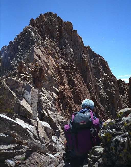
As Dawson recommends, we worked our way south-west to about 11,600 feet and then turned towards the east, straight up the ridge line. The first 1000 feet on this ridge line are pretty loose, crappy rock, but you eventually get up on top of the ridge and can settle in for a fairly easy walk to the east. During the climb of this 1000 feet, we met the two guys we had spotted earlier that morning coming back down. They said they ran into some nasty vertical walls and down climbs at about 13,200, and decided to turn around. We wanted to see what they were talking about, and if we could get any further, and it was still relatively early in the day. We continued walking the top of the ridgline for about 3/4 of a mile. Then things got interesting.
Dawson writes, and I quote "stick to the ridge all the way to the summit, making small deviations for gendarmes and drop-offs". When we reached the first "gendarmes and drop-offs" area, it took a couple minutes, but we eventually figured out where to drop-off the ridge line to the south for about 100 vertical feet, and where to crawl up through some notches to re-attain the ridge. This wasn't too difficult, although there was one place where a cairn indicated to go "south" just one more rockline, but the single step to get there was far too precarious. We just chose to climb up through a notch in the rock to the left of the cairn rather than go around. It felt safer than trying to make that one weird step around the point.
|
We got back up on the ridge line, and continued for another quarter mile, making only a couple of "minor deviations" to get around some bad spots (yes, these were truly "minor deviations"). We finally got up to about 13,500, only two minor "bumps" away from the summit, when we were stumped by what to do next. We spent about 20 minutes looking for where to go (definitely not to the north side, as it dropped almost vertically), and the south didn't look much better. We thought we saw a chute about 75 yards in front of us where you could conceiveably climb back up on to the ridge line, but didn't see a way to get to the base of this chute, and weren't really sure we wanted to crawl up the chute anyway. The "minor deviations for gendarmes and drop-offs" had stopped us cold. The rock up here was so bad that I'm not sure we could have used technical climbing equipment, even if we had some with us. |
|
To make it even worse, what we could see of the top (only about 150 yards away) would have been just as vertical as what was staring us in the face. From our perspective, it would have taken another hour or two just to get to the top, for a total of 6 hours, and then the climb down could have been just as tough, putting us back into camp at about 4:30 or 5pm which, as everybody knows, is WAY past "thunderstorm safe time". After a small bit of soul searching, we decided to turn around and head back. Considering a LARGE part of this ridgeline was very rich in iron, and that the rangers we met mentioned recent heavy lightning activity around the area, the decision wasn't all that hard to make, though. |
Both of us are still wondering exactly what Dawson meant by "minor deviations". I'd really hate to see what he calls a "serious deviation".
We made it back down to camp by about 3:15pm. It was a fairly easy walk down, except for that "1000 feet" I mentioned earlier. Once below that, we put on the gaiters, and scree-slid back down to tree-line. Normally my knees bother the hell out of me after a down-climb, but given only this 1000 feet of hard down-climbing, I actually felt great once we were down.
We went over to the lake hoping to clean up a little, and perhaps even take a quick "dip" to cool down. Chip brought his thermometer which we placed in the water, luckily before he walked in. The water was a brisk 49 degrees. A little too cold for "dipping". So we soaked our feet, killed some fish (a joke...), and just sat around for an hour staring up at the "gendarmes and drop-offs" that had stopped us. Oh well, the mountain will still be here when we come back to try a different approach, and will be just as spectacular, so we didn't feel too bad. We went back to camp, made dinner, popped a couple IB's for a good night's sleep, and called it a day.
The next morning we got up, packed everything up, and headed out. We made the five miles out in an hour and 45 minutes, and arrived to find the car had a flat tire. We put on the little "bicycle tire spare", and drove out the gravel road with the back end of the car fishtailing around like crazy. The view of El Diente from the south is wonderful, and we stopped to take pictures of the bluffs that stopped us from this side. When we get back to work, we'll have to hunt down somebody who's climbed the west ridge route successfully, show them the pictures, and ask "what did you do here".
We re-filled the flat tire on "Society Drive" in Telluride (I still can't believe that there's a road called that) and headed for home. We made it back in just about 7 hours, with surprisingly light traffic for a Sunday afternoon/evening, with two minor exceptions: An small 18-year old redneck with a huge black cowboy hat, in a huge pickup pulling a horse trailer (yes, it was as funny as it sounds); and a Denver church school bus with a sign that said "on the move" (which wasn't really true...). We made it back to Broomfield around 6pm, with enough daylight to set up the tent equipment, clean it up, and repack everything in preparation for climbing Capitol Peak in two weeks.
I managed to remove the moleskin from my feet playing sand volleyball doubles on Monday night, and now have two fairly significant blisters which damn well better heal by August 1st, or I'll be in real trouble. I've noticed the thread on Benzoin in rec.backcountry, and may try out that approach before we leave.
As Chip's T-shirt says: "Work Sucks: I'm going to the mountains" ============================================================================= Steve Parker Disclaimer - These opiini^H^H damn! ^H^H ^Q ^[ .... :w :q :wq :wq! ^d X ^? exit X Q ^C ^? :quitbye CtrlAltDel ~~q :~q logout save/quit :!QUIT ^[zz ^[ZZZZZZ ^H man vi ^ ^L ^[c ^# ^E ^X ^I ^T ? help helpquit ^D ^d man help ^C ^c help exit ?Quit ?q CtrlShftDel"Hey, what does this button d..."